Appalachian Trail Experience 2006: Just Gene

My AT adventure began on 4/4/06 at Springer Mtn was completed on 8/6/06 at Mt Katahdin. I averaged 18mi/day with an average pack weight of 40lbs. I resupplied every 2 weeks via mail drops and spent lots more money on food along the trail. I took a total of 8 days off spending 6 of them with my wife. I'm looking forward to doing it again...a bit more slowly the next time...:)

Monday, August 07, 2006

7/31/06 Monday: <<100 mile Wilderness>> ME15 to Cloud Pond Lean-to (19.1mi)


PICTURES:
1. Thats my bed in the bunkroom at Shaw's... very nice accomodation with a wonderful staff and guests made this stay memorable...
2. Picture of Shaw's guest house... I stayed in the back... Down the road I purchased additional snacks for the trip from the Monson General Store...
3. I cant seem to find their names but the guy in this picture is the chef and the woman is the administrator/maid/host. Both are quite wonderful and helped us all feel at home.
4. The guy in the previous picture is also their shuttler.... He drove me to the trailhead and took this picture just before I would enter the 100 mile wilderness...
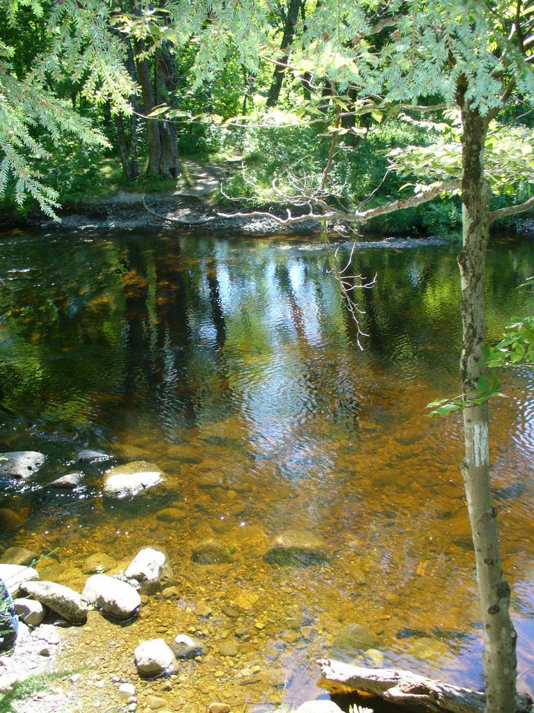
5. One of many ponds/lakes along the sides of the AT as it winds its way north through the wilderness..
6,7,8. A walk thru a devastated area hit by a microburst... You can see in 6 that the trail crew responsible for this section has done an extraordinary job at reopening the trail. The next picture just shows the terrain, rocks and shallow root systems, and gives you an idea how difficult life is out here... Picture 8 is taken from an elevated point back at the devastated area.
9&10. The lovely Little Wilson Falls... I took a few moments to witness the powerful water flow and majestic falls...
11&12. After some of the trails I have been on, walking on a gravel road is always well appreciated...:)... 12 is a view from a ridge of the pond I had walked along side just 30min earlier... The beaver pond is unnamed on my map but quite picturesque as I continue north toward the Barren/Chairback Mtn Range.
13. I spent a few moments chatting with my old friends pictured here "Slowpoke and Spindleshanks" a retired couple from South Africa whom I met earlier this year at Fontana Dam headed north. They reached Harpers Ferry, West Virginia and decided to fly to Maine and continue their journey south back to Harpers Ferry to avoid the possibility of arriving in Maine too late to climb Katahdin... Katahdin closes on October 15... In spite of their advanced age, they both were in remarkably good spirits and good health.. He is a retired Physician... They both recognized me immediately, as I did them, and I had to give them a hugg. I knew what they were going through and how trying the terrain and conditions were in Western Maine and through the Presidentials in NH... I have no doubt that they will succeed in their endevor to complete this journey, one of 10 long distance hikes they have planned to experience around the world...
14. I met these kids at the Long Pond Stream Lean-to... They were part of a larger group from Quebec passing through the wilderness based out of someplace near Greene, ME. The one boy on the right was from Conneticut, he opting to immerse himself in the French language for a few weeks with this group... The boys were very inquisitive and polite, all had done volunteer trail work on the AT during previous summers in Maine... It was a pleasure to have come into contact with such a well behaved, intelligent group of young men... Oh, by the way, the one with the white tee shirt and the buzzed hair... a few had opted for "unique" hair cuts to go along with the longest trek of their young lives...:)...
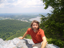
15. Me at the summit of barren Mtn on a long, hazy day... I've got the "I can't wait to call it a day" look in my eye...LOL...


I was excited about beginning the last leg of my journey on the AT.... Jackie had mailed me a package with 17 meals in it as well as some other necessary items... My pack weight was back up to about 45 lbs at the start ...:(... Soon enough though that would change... After a big breakfast at Shaws, they gave me a ride back to the trailhead on ME15 and after taking a picture by the sign there I entered the woods around 0730 and started heading north... It was a beautiful day, cool and breezy, and the first few miles were relatively easy with a number of ponds and streams passed along the way... I had my eyes out for moose, I had not seen one yet and wanted one for the blog... About 1000 I arrived at Little Wilson Stream and removed my socks and boots to ford the knee deep waters... It was an easy crossing, easiest of them all with small rocks on the bottom, the footing was even and the current was not too strong.. at 1330 I arrived at Big Wilson stream and again prepared to ford it... I recalled a gentleman back at Shaws with a cast on his leg who claimed to have twisted it in the large rocks while fording Big Wilson... The bottom was quite uneven and the current strong making this a difficult ford... But attacking it carefully with my trekking poles I made it across without incident... I took a break on the other side and soaked up some sun for a bit on the large boulders... At 1330 I arrived at the Wilson Valley Lean-to and took a 30 min break... It was the halfway point of the day with 2 1000' ascents to come this afternoon before my arrival at the Cloud Pond shelter later this evening... After my break I got some nice views from some open ledges before decending past a logging road to ford yet another stream, Long Pond Stream... This was another tricky ford with a strong current and water up to mid thigh in places... There was a group of teenagers from Quebec sunning themselves and relaxing in and around the water... The water was from a pond and not too cold, pretty nice actually... It was about 1600 and I decided to move up to the Long Pond Stream Lean-to and eat dinner.. I arrived there to find the other half of the 15 or so boys gathered around the shelter eating and chatting, mostly in french. My french is quite rusty so I kept to speaking english. Most of the boys spoke english quite well and those who had trouble were assisted by others... Another boy there was from Conneticut, the only American in the group. He and his parents chose this summer camp in Maine owned by this Canadian Group as a way to get immersed in the french language without having to travel out of the country... What a great way to practice your language skills... All were quite curious about my trek and the questions kept coming... I enjoyed their company quite a bit and took a picture of the group just before leaving... These kids also volunteer as work crews on the AT during their summer camp stay with many of them pointing out bridgework or water dams they helped make along the way... I continued on my way about 1730 with almost 1500' of climbing yet to be done before I would reach my camp at Cloud Pond on top of Barren Mtn. about 4 miles away... The climbing wasnt too bad and I was rewarded with some nice views from Barren Mtn before decending to the pond... I arrived at the pond about 1930 to find it almost full... Only one spot left in the shelter and no camping spots left.. I took the last spot in the shelter and cooked another meal which I quickly consumed and after chatting with the other hikers about their trips, I soon retired to my bag for the night...

7/30/06 Sunday: Moxie Bald Lean-to to ME15, (Shaws Boarding House), Monson, ME (17.9mi)


PICTURES:
1. I came in after dark last night and missed this beautiful view of Bald Mtn. Pond just 100' from the Lean-to..
2. I'm 50' from the water and the shelter... A lovely site, one of the most beautiful on the entire trail...
3. Some pretty nice trail mixed in with...
4. Some pretty mucky ones... LOL You have to take the good with the bad out here...
5. The West Branch of the Piscataquis river meets the main Piscataquis river posing a challenging stream crossing with thigh deep water and a strong current...
6. Had a nice long afternoon walk along the banks of the Piscatiquis river...
7. Another view of the East Branch of the Piscataquis river was
8. Trail Majic was waiting on the other side of the East branch ford... I took a break and indulged in the soda and sweets while chatting with a couple who were out day hiking...
9. Crossing the East Branch was quite a bit easier than the West Branch. Here is a look back across the West Branch from the trail Majic...:)

It was a lovely day again with plenty of sun and mild temps... I got some pictures of the shelter area and lake before packing up and heading out around 0800. I was really looking forward to the end of this day and my stay at Shaws... I had heard so much about the place and really wanted to experience it myself... The day would prove to be longer than I had anticipated due to poor trail conditions ie. lots of rocks, roots, and water with lots of little hills thrown into the mix... They served dinner at 1800 so I had plenty of time to make the 18 mi trek... I had covered 9 miles by 1200 and arrived at the Horshoe Canyon Lean-to for lunch. It was quite a hike to get water so lunch lasted about 90 min instead of the usual 60.. I started out just after 1330 on the second half of this perfect day with temps in the 70's and lots of sun.. There were 2 river crossings today requiring the removal of boots and donning of crocks, this makes a total of 5 fords so far and by far the east branch of the Piscatiquis River was the most difficult.. The current was strong and boulders large with crevases between and getting waist deep in places... Very tricky footing always makes fording a stream quite difficult.. The trekking poles are particularly useful at helping maintain balance and searching the bottom for solid footing... The events pushed my completion time further back to the point that I was fearful of missing supper so I doubled my efforts on the last 7 miles and finished at ME15 around 1700. I stuck my thumb out for a hitch the 3.5mi back to town and was picked up by a local blueberry farmer. A nice gentleman we chatted briefly and he offered to drive me back out after dinner. I declined graciously stating I would be spending the night before heading out first thing in the morning... He detoured about .5mi from his route to drop me off at the door of Shaws where I was welcomed by the owners and staff... A number of other section and thru hikers were residing there also and I would get to chat to them all throughout the evening... No computer was available leaving me plenty of time to socialize... We all had a large roast turkey for dinner with all the trimmings, perfectly done. The tables were buzzing with chatter about experiences gained on recent and past hikes and of hikes to come... A good time was had by all... I chose to stay in the bunkroom that ended up with only one other hiker. Later that night I was able to reach Jackie for a late night chat before signing off another day...

7/29/06 Saturday: US201 Caratunk, ME to Moxie Bald Lean-to (18.8mi)


\PICTURES:
1&2 The day started out quite nice with a 6 mile gradual climb to the base of Pleasant Mtn... Course there were the ever present blowdowns with the rock&root walk to keep you on your toes...;)
3. A look back during my ascent of Pleasant Mtn..
4. OHHH!!! Wild Blueberry's everywhere on Pleasant Mtn... mmmmmm very tasty too...:)...
5. A view north of Moxie Bald Mtn from the summit of Pleasant Mtn...
6. Passing bye Moxie Pond on the way to Moxie Bald Mtn...
7. I walked around the perimeter of this beaver pond near Bald Mtn Brook Lean-to actually walking on the sticks retaining the water in the pond... Much of the trail around this pond was relocated to higher ground due to flooding...
8. A rather large moose track on the way from the beaver pond... I came across many of therse but this was by far the largest... Never did get my moose pic..:(
9. Unique rock formation on the way to Moxie Bald Summit...
10. Open rock face of Moxie Bald Mtn. ... Incredible views in every direction...
11&12 Views to the SW of Moxie Pond from Moxie Bald Mtn...
13. Sunset captured during my descent from Moxie Bald Mtn... A fitting end to a gorgeous day... About a mile to go to the shelter at dusk...

After a great breakfast, Mr. Longley drove me the mile back to the trail head and set me on my way north... I thanked him for his hospitality and began another leg of my trip to Katahdyn... It was a very pleasant day with plenty of sun and a nice breeze. Temps were in the 70's and quite comfortable... By 1100, I had made the initial 5 mile trip to Pleasant Pond Lean-to and took a short break before starting the 1200' ascent in less than 2 miles.. The climb wasnt too harsh and soon I was standing on the baldsummit admiring the views in every direction.. I took a moment as I often do to phone Jackie and catch up on current events as well as remind her how much I do love her... It was a long descent to a logging road before my next challenge of the day... I stopped in to the Bald Mtn Brook Lean-to for dinner to regain my strength and tackle Moxie Bald Mtn... A 1500' ascent in less than 2 miles, with spectacular views from in every direction... As with most multiple ascent days, MoxieBald was slow going but I only needed to make it to the Lean-to on the other side of the mountain to end my day... I spent extra time on the summit to chat with my wife and other relatives before grabbing a sunset picture and heading down to the shelter... I arrived at the shelter at dusk to find 2 southbound section hikers already in their sleeping bags.. We chatted a bit while I cooked some dinner and set up my bag for the night... The shelter and multiple tenting sites are nicely situated in the NW corner or Bald Mtn Pond. I got a full appreciation of the beauty of the spot in the morning...:)...

7/28/06 Friday: Little Bigelow Lean-To to Rivers and Trails Hostel, US201 Caratunk (21.3mi)

\PICTURES:
1. Early morning view of Flagstaff Lake just 2 miles N of Little Bigelow Lean-to
2. I emerged from the woods on this road (Long Falls Dam Road) and was greeted by this mile marker... Put a smile on my face...:)...
3&4 Some very pleasant walking on this day made possible by the hard work of volunteers from the MOAC (Maine Outdoor Adventure Club)... I stopped to chat a bit with these two members and thanked them for all their hard work...
5&6. Thats Pierce Pond taken from the beach and again from the Pierce Pond Lean-to... A lovely setting...
7. Just north of Pierce Pond were some lovely water falls
8&9. The trails in Maine are noted for their primitive bridgework...Two fine examples are these just north of Pierce Pond...
10&11. A view across the Kennebec river to the ferry (canoe) on the other side just as the skies openned up... Years ago hikers were required to ford this river... After a few drownings the ATC decided to hire a ferry service to take the backpackers across... On this day the water was at least chest deep in some places, deeper in others...
12. Later that evening after cleaning up while having dinner...
13. A picture of the bunkhouse at River and Trails Hostel, pretty basic but for $14 a nice place to dry off for the night...


Well I got up and on my way early wanting to catch the last ferry crossing the Kennebec River. The ferry service, actually a canoe with a guy and a paddle...LOL... ended its afternoon service at 1600 sharp... NO EXCEPTIONS... I had a series of small mountains to cover along with a lot of rather level terrain and was confident I could make it in time... The day went by quickly with me keeping a 2.5-3.0 mph pace... No breaks were aloud, so I packed six power bars that would get me through the day in my hip pouch. Along the way I met a volunteer trail crew from MOAC (Maine Outdoor Adventure Club) of two and stopped to chat for a bit.. After taking their pics for my blog and thanking them for all their hard work they do, I pushed on. They suggested taking a moment at the Pierce Pond Lean-To and enjoying one of the prettiest settings on the whole AT... I passed the West Carry Pond Lean-to which was quite nice and some lovely terrain with wetlands and ponds scattered throughout before reaching the Pierce Pond Lean-to around 1300. I had less than 5 miles to go and decided to take a much needed 30min break looking out at the pond.... Very nice... At 1500 I finally arrived at the south side of the Kennebec River and after walking under cloudy skies all day, it finally decided to rain... It started coming down really really really hard... Within 20 minutes my shoes had filled with water, I was completely soaked, but thanks to my pack cover all my stuff was dry...:)... I waved the orange flag and at first the guide hesitated coming to get me, hoping the rain would slow for a spell.. But after about 15 minutes it actually was raining harder.... By this time we were both soaked and he started on his way across the river... I could see him struggle near the north side in the strong curren, but he made it across without incident... We decided to give the weather a few more minutes to see if it would slow a bit, it didnt..., before we dumped the couple of gallons in the canoe out and set off for the other side... He forgot the extra paddle so I couldnt help him navigate to the other shore. He struggled again on the north side and we landed about 50yds down river from the launch site... I helped him get his canoe back up the bank and began my 1 mile walk to the hostel up US201... In this weather no one was going to stop to give me a ride so I trudged along until the van from the hostel happened along, picked me up, and took me to the hostel... I checked in and got a hot shower washed and dried my clothes and got some nice junk food to eat to tide me over until dinner...:)... There were 2 other hikers there one heading north the other south... The northbound hiker was a retiree in his sixtees, in prime physical health from West Virginia... I was quite impressed with his abilities and we hit it off right away... All three of us were shuttled to dinner by the hostel owner at a restaurant about 1/2 mile up the road where we had a nice meal. The other northbound hiker and I returned for the AYCE breakfast buffet and really got our moneys worth...:)... The hostel had no electricity or running water so we retired to our bunks around 2030 for a good nights sleep hoping for improved weather tomorrow...

7/27/06 Thursday: Stratton, Me ME27 to Little Bigelow Lean-To (15.3mi)

PICTURES:
1. I was excited about revisiting the Bigelow Range... It had been nearly 30years since I had crossed first crossed these peaks.
2. A view of the Horns of Bigelow Mtn taken during my ascent
3. A unique early design of the Horns Pond Lean-to
4. View from South Horn of West Peak 2 miles away
5. Thats me at the summit of South Horn
6. View back at Horns Pond .75mi away
7. Clouds began to move in and it started to rain as I summited West Peak ...


I rose around 0600, gathered all my gear and brought it downstairs. All the others were still asleep so I wondered over to the diner across the street for breakfast. Unfortunately, they did'nt open till 0700, so I went to the convenience store to purchase my snacks for the coming week. Plenty of activity over there... Fishermen preparing for a day out, truck drivers with their load of lumber stopping in for coffee, and a few local men chatting with the owner... I picked up an assortment of powerbars and snickers, about 15 all together... Enough for about 3 days... I was planning to stop in Caratunk for more snacks and a shower in 2-3days. So I finished my shopping and ventured back over to the now open diner for breakfast... I ordered my usual double breakfast of an omlette and stack of french toast; enough to carry me up to the multiple summits of the Bigelow Range. After breakfast I returned to the hostel, found one of the owners, and got my ride back to the trail head arriving around 0845. It was a nice day, partly cloudy with mild temperatures. My pack was relatively light, with half my meals eaten and my last major resupply not till Monson about 6 days away... I had a 20+ mile day planned but with the late start was already thinking about shortening it up... I arrived at Horns Pond Lean-to about 1100 and took a few pictures... I pushed on to South Horn, arriving around 1230, and was awed by the marvelous scenery. I took an hours break while enjoying the view and watching the clouds blow past... I noticed a weather system approaching and decided I best be going. I had 2 more exposed peaks to summit today and didnt want to be caught on a summit during a severe T-storm. By the time I reached West Peak, it was drizzling and the clouds blanketed the mountain eleminating any possibility of another view on this day. I could hear intermittant thunder in the distance, so I pushed on hoping to clear Avery peak without incident.. I passed through Avery Campsite to get a feel for this unique area, not finding a single camper... I pushed on up toward Avery peak, the highest of the 3 peaks. The clouds were getting thicker and the trail more challenging... I came across a lovely spring beside the trail and filled both my bottles with the ice cold crystal clear, sweet tasting water. Definately one of the highlights of the day... I continued up to Avery peak which was completely covered in clouds with a gentle mist falling. I snapped a picture and continued down the east side of the mountain... It was not 1500... I had covered the 8.5 miles to Avery peak in 7 hours, the steep terrain and difficult footing along with the poor weather all taking its toll.. At this point I decided to shorten my day by setting my sights on the Little Bigelow Mtn Leat-to for the night. The descent was not too bad and I soon arrived at the Safford Notch campsite, off the mountain and heading on a somewhat long (3mi)gradual climb over the multiple false summits of Little Bigelow Mtn.. Eventually (about 1700),I reached the final summit of Little Bigelow and began my descent to the Little Bigelow Lean-to. I soon found myself passing through a trail ripe with blueberries. With 1.5 miles to the shelter and about 3hrs of light left I decided to stop and pick some :)... After about an hour and a few pints of blueberries, I continued on to the shelter, arriving around 1900. I joined a southbound hiker there from Texas and we chatted over dinner. After finishing dinner we continued to discuss some of the trail conditions each of us were to encounter in the days to come and finally retired for the evening around 0830.