Appalachian Trail Experience 2006: Just Gene

My AT adventure began on 4/4/06 at Springer Mtn was completed on 8/6/06 at Mt Katahdin. I averaged 18mi/day with an average pack weight of 40lbs. I resupplied every 2 weeks via mail drops and spent lots more money on food along the trail. I took a total of 8 days off spending 6 of them with my wife. I'm looking forward to doing it again...a bit more slowly the next time...:)

Friday, May 26, 2006

5/24/06 Wednesday: Punchbowl Shelter to Seeley-Woodworth Shelter (25.3mi)


PICTURES:
1. I had to take a pic of this lovely setting at the Punchbowl Hut/Campground where I spent the night
2. Here's something you don't see much...a well groomed and level section of trail...:)
3. I could see the remnants of the Brown Mtn community throughout my hike along the creek.
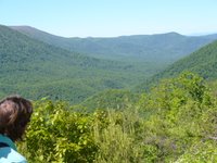
4. Views from Cold Mtn...
5. Walking across the grassy tops of Cold Mtn.

Some rather rugged climbs lay ahead today, but I was undeterred... I wake from a good nights sleep to near 55 degrees. Thats about as warm a morning I have had yet... Had plenty of sun right from the start today too...that makes it all the better...:)... By1045 I reached the Brown Mtn Creek shelter, about 10mi. of rather easy walking...Unfortunately I had a 3000ft mtn coming up... I'm beginning to not like that very much...LOL... I took a 30 min break and decided I best get on with it... so I crossed the James River over to US60, where I was able to talk with Jackie for the first time in 3 days... I tried making making more calls while on the road but to no avail... After wasting about 30 min walking up and down the road I decided to move on... But not till some Trail Majic from some section hikers... They gave me some snack and took my trash... Grinz...its the little things that really count out here...;) After finally heading out from US60, I reached a little beyond the summit and had wonderful vistas for more than an hour...At about 1400, I had dinner near the Cow Gap Shelter. I say near because the shelter is .6mi off the trail...the water was .5mi... So I left my pack on the trail and ran down the half mile for the water and back up... It took about 20min round trip and I took another hour for dinner... Water up on the ridge would prove to be a scarce commodity and it would prove to be a worthwhile venture to have spent the time here getting it... I had 10 more miles till the end of my day with all the tough climbs behind me, I would arrive at the Seelelhy-Woodworth Shelter around 1915.

5/23/06 Tuesday: Thunder Hill Shelter to Punchbowl Shelter (25.1mi)


PICTURES:
1. Vista from Thunder Tidge Overlook BRP
2. Fields of blooming Trilium
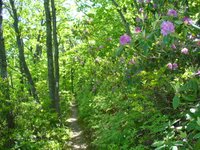
3. Path through blooms of rhododendrums are becoming more frequent...
4. These wildflowers are beginning to line the trails through the Blue Ridge...
5. What can I say...Mountain Loral...and they are fragrant too...
6. Vista from my ascent of High Cock Knob
7. While crossing the James river bridge I noticed these turtles sunning themselves...
8. Vistas from Fullers Rocks, on the north side and looking back on the James River
9. Sunset views from Punchbowl Mtn
It was actually a little warmer when I woke, 0645, and I was soon on my way. I have found the easiest way to warm yourself in the morning is to hit the ground running...;)... It was a beautiful morning, again... and temps were soon in the 60's with plenty of sun...The mornings walk was uneventful and passed by quickly and by 1215, after 12mi, I had arrived at Matts Creek Shelter for lunch and stock up on more water for the afternoon... The afternoon flew by with some nice vistas and really beautiful weather... Late in the afternoon I was startled by a grouse... I apparently was invading her territory and there were probably chicks about... She ruffled her feathers but apparently didnt like the flash on the camera, which sent her running off... Soon thereafter I arrived at my final destination around 2000, and what a beaautiful setting it was with the shelter by a pond with an adjacent grassy camping area.... About 2100, when I was tucked away in my bag, in my tent for the night, a whole bunch of owls began arguing... Must have went on for about 45min...LOL... I had heard the calls before, but not by so many, from so many different directions... It really made you feal you were in the wilderness...

5/22/06 Monday: Bobblets Gap Shelter to Thunder Hill Shelter (23.6mi)


PICTURES:
1. Nice vista from this overlook close to the "turkey episode"...LOL...
2. Thats yours truely standing in front of Bryant Ridge Shelter, a new and rather unique design. I had lunch here...
3. Met this Husband and Wife team each with their dog section hiking south. We chatted over lunch
4. Picture taken from "Black Rock" around 1800
5. Thats me again relaxing and enjoying the vista from Apple Orchard Mtn (4225")
6. An interesting rock formation call the Guillotine

I woke up energized after yesterdays big day with hopes of even more miles today and at 0745 I was off... I was walking on the AT along side of the Blue Ridge Parkway (BRP) and expected some easier terrain. Well, the terrain wasnt much easier...LOL... I think its just us hikers are in better shape... ;)... Anyway, A couple of miles out the strangest thing happened... I startled a rather large wild turkey who commenced to flying across my path, stopping me in my tracks. I reached for my camera while this bird continued gobbling and literally started running circles around me. LOL... I wasnt sure what to think or do, and the darn thing wouldnt stop for me to get a decent picture... It must have ran 6-7 times around me, staying about 30 feet away all the while. It finally flew away, clumbsily and I continued on my journey, still wondering what just happened. I was later told that the turkeys are now nesting and the turkey was probably just trying to draw my attention from the chicks... Ahhh... spring...aint it wonderful...LOL... After 7 miles, I stoped in about 1015 at the Cove Mtn Shelter for a 20 min break and snack. The morning weather had been cool and cloudy and the sun had just come out...:)... I was soon on my way and by 1315 and 6 more miles I reached Bryant Ridge Shelter for a 1 hour much needed lunch break... I had a 2000ft climb after lunch that I wasnt looking forward to...:(.... And it proved as touch to accomplish as it looked on the map... at about 1700 and5 miles later I came to Cornelius Creek Shelter where I took a break and chatted with a young day hiker with Yoshi popping in about the time I was about to leave. Yoshi decided to stay where he was, and the day hiker left for a side trail to the BRP where his dad was picking him up. My plans were to be in Waynesboro by Saturday to meet an old friend I had not seen since High School, so I decided to get to the next shelter since the weather was so wonderful...and you never really know what tomorrow will bring... I finally arrived at Thunder Hill Shelter around 2030...no need for the headlamp tonight...:)... The night would prove to be quite chilly, dipping down into the low 40s... Our elevation was 3960... pretty high up... and usually 10 degrees cooler than in the valleys...

5/21/06 Sunday: Troutville, VA to Bobblets Gap Shelter (18.5mi)


Greetings from Waynesboro, VA...the southern entry point to Shenandoah National Park and Skyline Drive. The AT criss-crosses Skyline Drive throughout the 105mi picturesque trip and I am looking forward to a rather easy week of hiking... I'm staying at the Super 8 Motel here, the only place with internet access for a reasonable price. I didn't know at the time it had a dial-up modem and a pre 2000 computer system...LOL... So needles to say... no pics today... I will add pics ASAP.

Well on Sunday the 21st, Jackie and I packed up early, had the nice continental breakfast at the Comfort Inn and head for The Natural Bridge, about 30 miles north of Troutville. We were both awed with the emense structure that is all but hidden from view by the owners. We walked through and took some pics, one of an engraving by a young George Washington who climbed 20ft up way back when this location was originally being surveyed for the King of England. Amazing......

I got dropped off back in Troutville about 1315, Jackie and I bidding each other farewell as she headed back to Dulles Airport near DC to catch her plane and me continuing on my journey north. We had a wonderful 2 days together... and plan another rendevous a month or so down the line..

My day started off beautifully, I was all carb'd up and was ready to go...LOL... The weather was beautiful and there were quite a few day hikers out enjoying the sights and sounds of spring in VA. It was quite warm, and I was thankful for some the spring water along the way... By 1730 I had made it to my original destination for that day and had dinner. There was still plenty of sun and warmth in the air so, I decided after supper to head for the next shelter, just 7.5 more miles up the trail... It would prove to be my first experience with night hiking, and with my trusty headlamp I made it into Bobblets Gap Shelter by by 2115. There I was surprised to meet Tater, Yoshi, Rainbow Bright and his partner. After getting reaquainted, we all turned in for a peaceful nights sleep.
PICTURES:
1. Jackie and I at the Natural Bridge
2. GW's (George Washington) initials carved into the rock by him as a teenager when this land was being surveyed for the King of England... That's cool.....
3. Poster
4. I crossed some pastures, private lands I believe, as I was leaving Troutville.
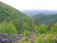
5. Some nice views with rhododendrums blooming in the foreground and Troutville in the background.
6. I snapped this sunset picture before decending to the shelter area.