7/21/06 Friday: Carlo Col Shelter to Baldpate Lean-to (16.4mi)


PICTURES:
1. 0737 I'm at 3200' walking over bridgework through a wetland area with Goose Eye Mtn in the distance.
2. 0835 Been climbing through bogs for an hour approaching Goose Eye Mtn...
3. 0848 East Peak of Goose Eye Mtn looking @ N peak
4. 0855 More bridgework during my descent of this very sensitive area.
5. 1054 Thats the rock surface of (AT) Goose Eye Mtn S peak... Not much soil for the vegetation...
6. 1126 Yes thats ice under that rock... The temperature in Mahoosuc Notch dropped 30 degrees... You could feel the cold air as you walked through it... Like standing in front of an open refredgerator.
7. 1128 LOL nice trail huh... Took me almost 2 hours to travel the 1 mile through this notch...
8. 1147 This passage through the rocks was too small for both person and pack... only one at a time...
9. 1150 More ice
10. 1150 You see that arrow (double click on the pic)... the AT goes through that small hole... There were about 4 such small passages down here.
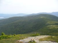
11. 1415 I'm near the top of the Mahoosuc Arm looking back at the Mahoosuc Notch and the multiple peaks of Goose Eye Mtn.
12. 1421 Between Mahoosuc Arm and Speck Pond lay a field of wildflowers... What a beautiful sight to behold...
13. 1423 At 3500', Speck Pond is one of the highest bodies of water on the trail...
14. 1726 Climbing Old Speck the weather changed and a light mist began to fall... Unfortunately no views today from Old Speck:(
I rose to another beautiful day and headed out by 0615. I stopped in at he Full goose shelter for a break at about 0945 and was prepared to whatever was to come. Shortly thereafter I carefully began my descent into Mahoosic Notch. Once down inside the notch, the temperatures dipped about 20degrees. I could feel the cold rush of air occationally, like standing in front of an open freezer. I could see solid blocks of ice clearly hidden beneath large boulders, ice that never melts... The northern end of the notch had a rapidly flowing brook under the rocks that I got glimpses of occationally between the large boulders. I had to take my pack off about 3 times to squeeze myself and then the pack through a small opening between the boulders... It would prove to be my slowest mile on the entire AT taking about 2hours to complete. Keep in mind, I normally average 2.0 mph. I began my ascent up the Mahoosic Arm (north side of the notch), a 1300" climb in less than a mile. By 1500, I had reached Speck Pond shelter, exactly 10mi from the start of the day... Once there a light rain began to fall and I considered ending my day. By 1600 the rain ended and I decided to push on to the next shelter, about 7miles away... It would be a relatively easy undertaking with a 2mi ascent to Old Speck, followed by a 3 mile descent to hwy26 and a 2.5mile ascent to Daldpate Lean-to. I arrived at the Baldpate Lean-to about 2015. I had a hot meal and retired shortly thereafter.. Definately one of the most exhausting days of my entire trip.


1 Comments:
Did you rest your weary feet in the Water by Screw Auger Falls at the base of Old Speck? I imagine the blackflies were pretty voracious this year in that area. Screw Auger is one of my most "special places". I'm so happy to be reading about it thru your eyes.
Hugs,
Dot
Post a Comment
<< Home